
CERC — Environmental Software and Services
- Overview
- Atmospheric dispersion
- Atmospheric chemistry
- Urban air quality
- Regional to local air quality modelling
- Vehicles and roads
- Aviation
- Emissions
- Urban heat island
- Atmospheric boundary layer
- Wind energy
- Hazardous releases
- Inverse dispersion modelling
- Net Zero
- Model evaluation
- Smart cities
- Web platforms
- Older projects
- CERC co-author publications
- CERC software publications
- Presentations
Older projects
This page gives brief descriptions of older completed research projects in a variety of fields, while current or more recent projects are given on the pages for each research topic. Please use the table below to navigate to information about specific projects on this page.
| Project title | Keywords | Date |
|---|---|---|
| GENESIS: GENeric European Sustainable Information Space for Environment | air quality, ICT | 2008-2011 |
| TRAPOS: Optimisation of modelling methods for TRAffic POllution in Streets | dispersion, street, traffic | 1997-2001 |
| Dispersion modelling of air pollution in urban areas of the UK (I and II) | 2001-2006 | |
| Noise mapping | 2005 | |
| PASODOBLE: PROMOTE Air Quality Services integrating Observations - Development Of Basic Localised Information for Europe | forecasting, model evaluation | 2010-2013 |
| STOPP: Simulation TOols for Pollutant Prediction | chemistry, model intercomparison | 2000-2003 |
| PROMOTE: PROtocol MOniToring for the GMES service Element Atmosphere | air quality, forecasting, airTEXT | 2004-2009 |
| TRAMAQ: TRAffic Management and Air Quality | vehicle, traffic, emissions, drive cycles | 2002-2004 |
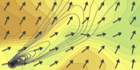
GENESIS: GENeric European Sustainable Information Space for Environment[top]
The object of the GENESIS project is to provide Environment management and Health actors with an efficient solution based on advanced ICT to constitute collaborative information networks, integrating existing systems. The proposed solution is based on a thematic-neutral and open information system set up framework made of web services, portal components and toolkits. This framework can be easily customized for various thematic fields e.g. air quality, water quality, and deployed in many contexts (regional, European...).
(Click to enlarge)
CERC are working with the University of the West of Scotland and Imperial College of Science, Technology & Medicine on an air quality thematic pilot based on London. The air quality thematic activity focuses on developing and evaluating health applications based on GMES geo-spatial air quality mapping services. The London pilot considers local scale air quality, different target groups and delivery modes e.g. web, GIS.
Supported by the EU 7th Framework.
Learn more
- GENESIS website.
TRAPOS: Optimisation of modelling methods for TRAffic POllution in Streets[top]
Research for TRAPOS was undertaken as part of an EU sponsored research training network. CERC's role included developments of theoretical models for traffic induced turbulence and the development of formalised scientific model evaluation procedures.
Learn more
- TRAPOS website
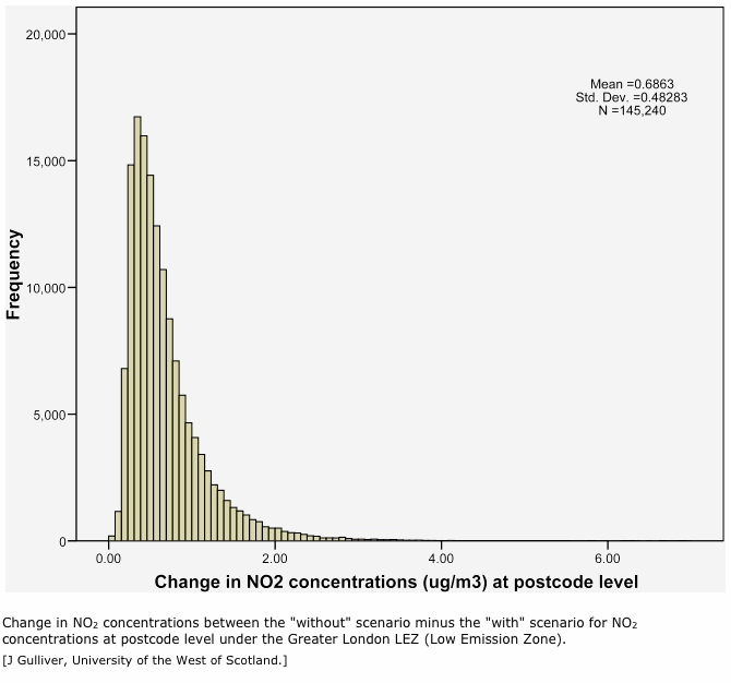
Dispersion modelling of air pollution in urban areas of the UK (I and II)[top]
Between 2001 and 2006 CERC was commissioned by Defra to carry out these major studies, modelling air quality in urban areas of the United Kingdom using ADMS-Urban. The project involved detailed modelling of NO2, PM10, PM2.5 and ozone for current and future years in London, Glasgow, Cardiff and Belfast. Extensive emissions inventory work was undertaken and there was considerable model verification and sensitivity analysis. The projects also included source apportionment, options appraisal and local dispersion at airports.
Learn more
- Comparison of ADMS-Urban, NETCEN and ERG air quality predictions for London(.pdf, <1MB)
- Modelling air quality for London using ADMS-Urban(.pdf, 9MB)
- Source apportionment for London using ADMS-Urban(.pdf, 17MB)
- Validation and sensitivity studies of ADMS-Urban for London(.pdf, <1MB)
Noise mapping[top]

Noise mapping is an integral part of developing an ambient noise strategy, and for ensuring that current and future noise levels are in compliance with existing UK and EU legislative standards.
CERC was involved in the production of noise maps for Leicester and Nottingham as part of Defra's Noise Mapping England project.
Reports and publications (Institute of Acoustics conference paper, assessment document and Cambridge noise mapping) in pre-2005 publication list are available upon request.
PASODOBLE: PROMOTE Air Quality Services integrating Observations - Development Of Basic Localised Information for Europe[top]
PASODOBLE was an EU-funded collaborative 7th Framework Programme project with 21 partners coordinated by DLR. It had a number of key objectives focusing on improving air quality in the EU through:
- Evolution of existing and development of new sustainable air quality services for Europe on regional and local scales;
- Development and testing of a framework for the coordination of input data and customizable user-friendly access to services;
- Promotion and harmonisation of best practice tools for air quality forecasting.
CERC's main role was the coordination of one of the four PASODOBLE services namely: local forecast model evaluation support service for local authorities and city bodies. This involved the development of a web-based air quality forecasting evaluation service. The other services were health community support services for people at risk, hospitals, pharmacies and doctors; public air quality forecasting for regions, cities, the tourist industry and sporting event organisers, and support services for compliance with the EU limit values for regional environment agencies. CERC also had a significant role in the public air quality support service through the development and use of the air quality forecasting system airTEXT with a focus on the London Olympic Games in 2012.
Learn more
- Model evaluation from PASODOBLE
STOPP: Simulation TOols for Pollutant Prediction[top]
Research for STOPP was undertaken as part of an EU sponsored research training network.
CERC's contribution included comparison and practical implementation of a range of chemical reaction sets including the CBMIV reaction set that can now be used as an advanced option in ADMS-Urban.
PROMOTE: PROtocol MOniToring for the GMES service Element Atmosphere[top]
CERC's forecasting systems for London (www.airtext.info) and Vienna were developed under the ESA-funded PROMOTE programme. They are described further in the Air quality forecasting section. PROMOTE is a programme on air quality and ultraviolet forecasting at the European, national and local scales.
The forecasts of regional background concentration that are used by ADMS-Urban make use of satellite and ground based measurements and a range of models for different spatial scales. ADMS-Urban is then used to provide high resolution local forecasts.
The project is sponsored by the European Space Agency/Framework 6 Global Monitoring for the Environment and Security programme (GMES).
TRAMAQ: TRAffic Management and Air Quality[top]


(Click to enlarge)
As part of the DfT's TRAMAQ research programme, CERC worked with Transport & Travel Research Ltd (TTR) and Millbrook vehicle testing center to develop an emissions calculation software tool for local authorities.
The tool used the latest data on HGV emissions in urban areas under a variety of drive cycles to allow users to take into account the impact of traffic management schemes on vehicle emissions. It calculates emissions of local air quality pollutants and greenhouse gases from road links. TRAMEC has an integrated GIS Mapper and a Picture book from which users selected a drive cycle.
The emissions calculator was piloted with local authorities in the spring of 2004.
Learn more
- TRAMEC user guide (.pdf, 6MB)