
CERC — Environmental Software and Services
- Overview
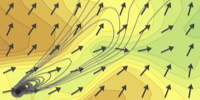
- Atmospheric dispersion
- Atmospheric chemistry
- Urban air quality
- Regional to local air quality modelling
- Vehicles and roads
- Aviation
- Emissions
- Urban heat island
- Atmospheric boundary layer
- Wind energy
- Hazardous releases
- Inverse dispersion modelling
- Net Zero
- Model evaluation
- Smart cities
- Web platforms
- Older projects
- CERC co-author publications
- CERC software publications
- Presentations
Urban air quality
Quick links: Scenario tool Cambridge transport WM-Air Ireland mapping Low traffic neighbourhoods Optimising with sensors CAMS Zagreb Defra Evaluation CureAir Source apportionment AIRPRO PROMOTE ADMLC reviews Smoke control
The air quality in urban areas is currently a subject of acute public interest as air pollution is one of the greatest environmental risks to health and many cities worldwide exceed targets for pollutants such as NO2 and PM2.5. CERC's model ADMS-Urban can be used to investigate urban air quality at street-scale resolution throughout an urban area, allowing for the dispersion of all types of pollutant emissions including those from road vehicles, domestic and industrial combustion and other forms of transport such as non-electrified railways.
Accurate estimates of pollutant emission rates are key to successful modelling of urban air quality. CERC's EMIT tool can be used to combine activity data, such as traffic counts, with emissions factors and vehicle fleets which can be adjusted to reflect local conditions or specific interventions such as low-emission zones.
ADMS-Urban has been developed to include detailed representations of local dispersion effects relating to road sources, such as street canyons, road tunnels, road elevation and noise barriers.
There are many accessible and informative formats for presenting air pollution datasets to the public. Some examples of online applications of high resolution ADMS-Urban model output are described here.
When modelling over domains which are larger than city-scale, it can be important to take into account variations of meteorological and regional concentration conditions across the domain. CERC's Multi-Model Air Quality System, MAQS, combines the ADMS-Urban model with outputs from mesoscale meteorological modelling and regional air quality modelling to allow consideration of the effects on an urban area of emissions over a wider region. Example project applications are described here.
Air pollution scenario impact tool for London councils
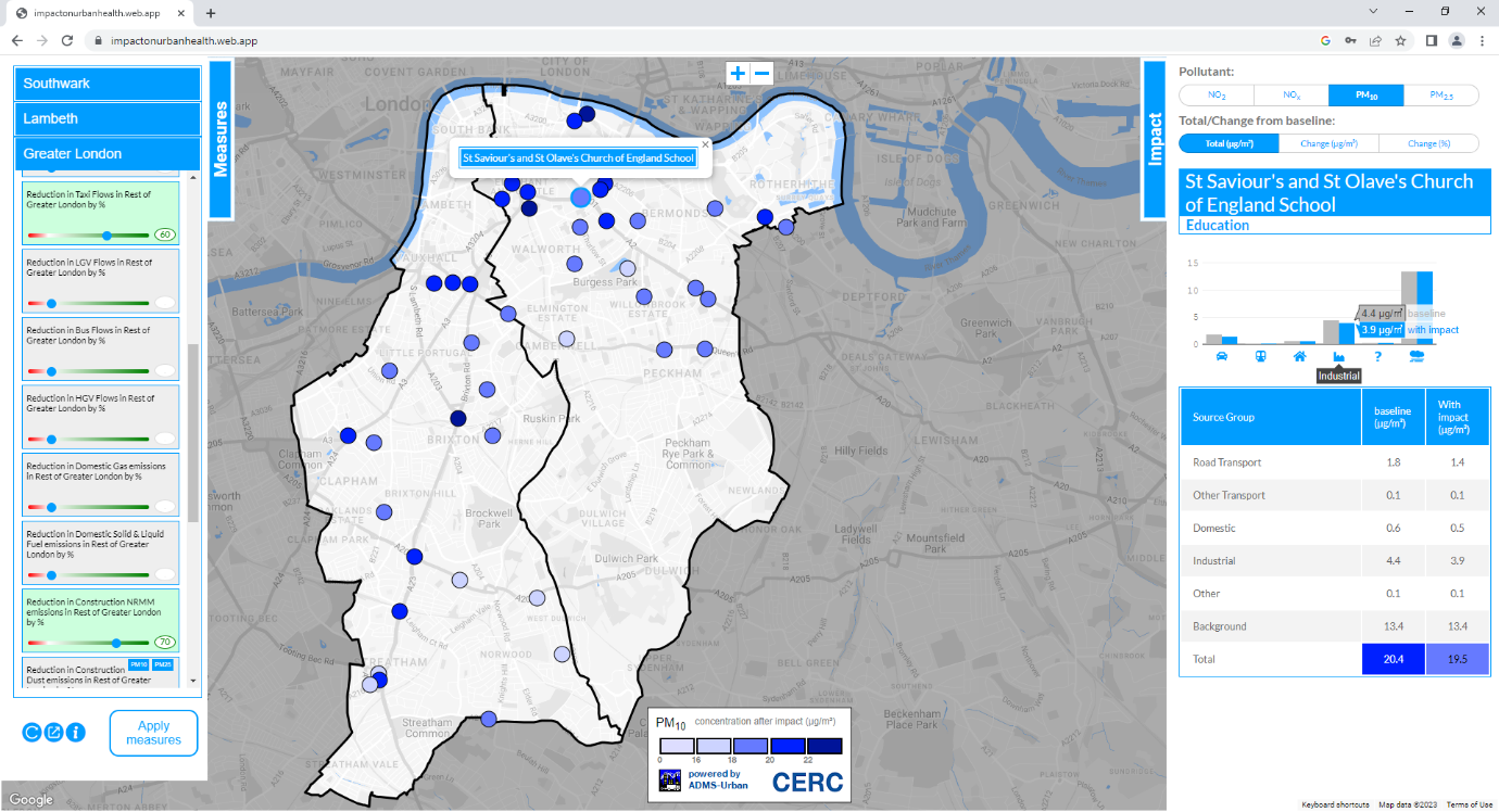
Impact on Urban Health (IoUH) and Southwark and Lambeth Councils have a shared ambition to reduce the harmful impact air pollution has on people's health, particularly those most at risk. With this objective in mind, they jointly commissioned CERC to develop a digital air pollution impact tool to model the impacts of changes to air pollution sources, and the adoption of mitigation measures, on levels of air pollution exposure. The tool is potentially scalable to all London local authorities, and is a 'ground-breaking' example for city authorities around the world, as are CERC's Breathe London and airTEXT services.
CERC selected sensitive locations in Lambeth and Southwark according to the risk from air pollution exposure and focusing on areas of deprivation, according to Indices of Multiple Deprivation (IMD) values. The team used ADMS-Urban to calculate concentrations of NO2, PM10 and PM2.5 at these locations and calculated the contribution of different source groups at each location.
Project results allowed the identification of measures that affect exposure to air pollution at each location, such as changes in traffic movements, emissions performance of vehicles, or the use of different fuels for heating and cooking. The impact of each measure on exposure to the pollutants was modelled at each sensitive receptor site. CERC's web-based interactive tool encapsulates the model results and allows the user to view the impact of different combinations of mitigation measures.
The health impacts of mitigation measures were assessed using the modelled concentrations in combination with population, age and health data. Project results and the methodology used for the work can be found in our report. In 2025, CERC will review the model, checking usability and updating inputs where new data has become available.
Modelling air quality impact of transport schemes in Cambridge
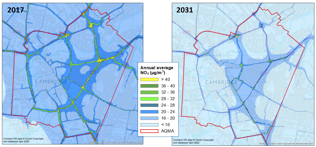
In 2018, the Greater Cambridge Partnership (GCP) commissioned CERC to set up a baseline air quality model for Cambridge to enable assessment of the air quality impacts of a range of transport options. Automatic Number Plate Recognition survey and council bus data were used to derive baseline city-specific fleet composition data for Cambridge, which was projected forward to future years using national fleet projection data and Council data on the expected bus fleet composition. This fleet data was used together with traffic model data as input to CERC's emissions inventory tool EMIT for the baseline road traffic emissions calculations. Changes to traffic activity and fleet composition were made within EMIT to represent the different transport schemes, including:
- A new fleet of electric buses;
- 'Greenways' to provide access to Cambridge from surrounding areas;
- 'Corridor schemes' to facilitate the use of public transport and active travel; and
- A plan for major bus improvements, to be funded by a congestion charge.
Modelling was carried out using ADMS-Urban to generate high-resolution concentration maps of NO2, PM10 and PM2.5. The figures show the baseline annual average NO2 concentrations for 2017 and 2031.
GCP was set up in 2014 to manage delivery of a £500 million City Deal investment over 15 years to create growth in the Cambridge area, focussing on infrastructure, housing and skills. GCP is a partnership between Cambridge City Council, South Cambridgeshire District Council, Cambridgeshire County Council and the University of Cambridge.
WM-Air: Air quality modelling in the West Midlands
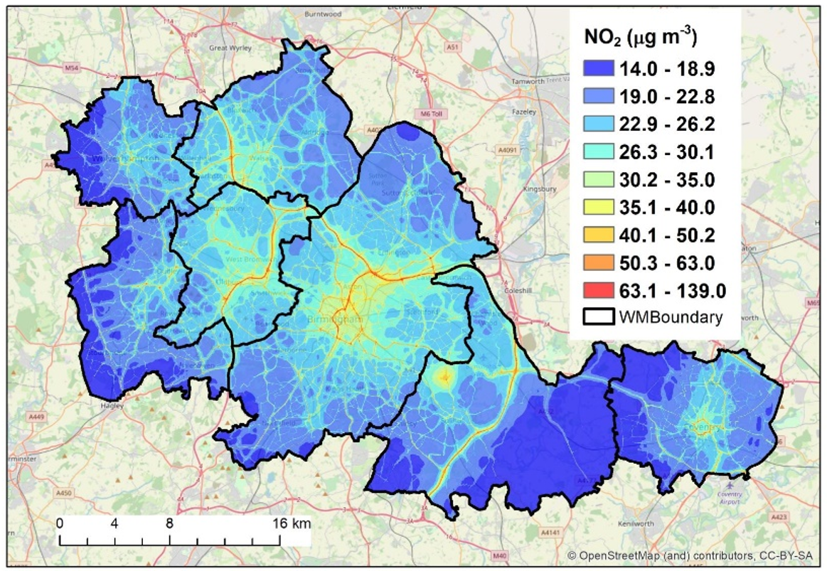
WM-Air: 'Clean Air Science for the West Midlands' was an impact-focused programme to support improvement of air quality and associated health, environmental and economic benefits in the West Midlands combined Authority area, encompassing Birmingham, Coventry, Dudley, Sandwell, Solihull, Walsall and Wolverhampton. This Natural Environment Research Council-funded, multi-strand project led by the University of Birmingham ran for 5 years. CERC were contracted to set up the baseline ADMS-Urban model configuration, using Transport for the West Midlands traffic data amongst other data sources. The University of Birmingham team refined CERC's baseline configuration, including adding traffic data from Birmingham City council. The large domain (900 km2) model configuration was executed efficiently on the University's High Performance computer using ADMS-Urban's spatial splitting option (the image shows baseline annual average NO2 air pollution maps in µg/m3 at 10 m by 10 m spatial resolution, further results published here).
Dr Jian Zhong then developed the model to represent a number of current and future air pollution mitigation scenarios, for example relating to the Birmingham Clean Air Zone, vehicle electrification and COVID. Some of the results of Jian's modelling fed into the Air Quality Lifecourse Assessment Tool (AQ-LAT), which is an openly available tool that can evaluate the health and economic impacts of current and future air quality scenarios in the West Midlands region. AQ-LAT was developed by researchers in the Institute of Applied Health Research at the university. Jian has also used the model to evaluate the impact of net zero policies on air quality in the West Midlands, as well as configuring and evaluating ADMS-Urban to model particle number concentrations.
As part of this collaboration, CERC also supported the University of Birmingham with their CMAQ regional model set up, including developing the EMIT emissions database tool to generate CMAQ format 3D emissions grid files from 2D gridded data and suitable vertical and temporal profiles. CERC's MAQS coupled system (formerly the ADMS-Urban Regional Model Link, RML) was then configured to investigate the relative impact of national and local emissions reduction policies on PM2.5 concentrations in the West Midlands (system set up details published here, with outcomes of the scenario modelling here).
CERC have a role in the current WM-Net Zero (WM-NZ) project funded by the Wellcome Trust, which follows on from WM-Air, and is also led by the University of Birmingham. WM-NZ is working towards linking policies to achieve net zero carbon emissions with positive health outcomes. The project will produce a toolkit that can estimate the health and economic impacts of net zero policies, using air pollution as a determinant of health. CERC's Associate Director (Research), Dr Jenny Stocker, is co-leading the Environmental Modelling strand of the project, with Professor William Bloss.
Street-scale pollution maps for Ireland
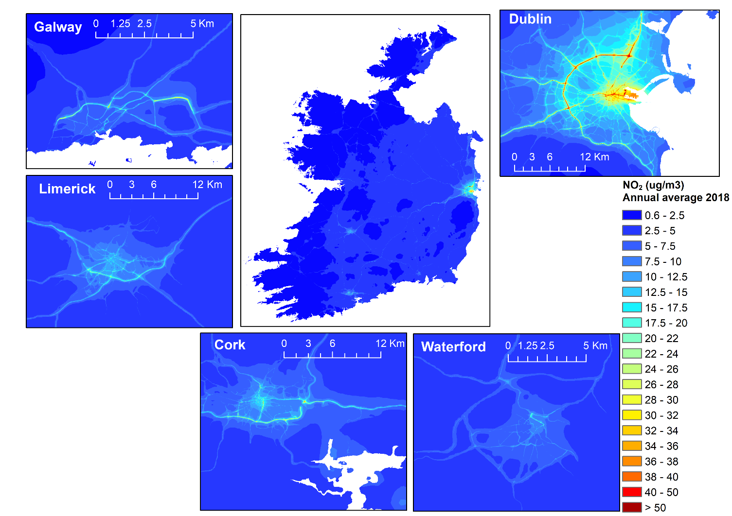
CERC were commissioned by the Irish EPA to provide street-scale modelling of Ireland for 2018 and 2019. The MAQS coupled system was used to link regional scale hourly pollution predictions from the EMEP model with local ADMS-Urban modelling. The UK Centre for Ecology & Hydrology (UK CEH) ran the WRF mesoscale meteorological model and EMEP chemical transport model with 1 km horizontal grid resolution over Ireland. CERC carried out detailed road traffic emissions calculations in EMIT based on traffic flow data supplied by the National Transport Authority (NTA) and Transport Infrastructure Ireland (TII). Gridded emissions from non-traffic sources were obtained from the MapEire inventory.
Selected results from the modelling have been published as part of the Irish Environmental Protection Agency (EPA) report 'Air quality in Ireland 2022'. The full CERC report with high-resolution maps for a wider range of regulated air pollutants is also available. The predicted concentrations were evaluated by comparison with measured concentrations, showing generally good performance for both years at all site types and meeting the FAIRMODE model quality objectives. Modelled concentrations were compared to current Irish air quality standards, with exceedances generally associated with the major road network. Most of Ireland meets the World Health Organisation (WHO) guideline for annual average NO2 concentrations, with exceedences in urban areas, while a substantial proportion of Ireland does not meet the lowest guideline for annual average PM2.5 concentrations.
Street canyon effects on dispersion were included in the 5 main cities: Dublin, Cork, Waterford, Limerick and Galway. Three major road tunnels were also included in the modelling using the ADMS-Urban tunnels module, with high concentrations noticeable around the portals of the Dublin Port tunnel. The model output is at hourly temporal resolution and irregular spatial resolution. The MAQS PostProcessor utility was used to calculate annual average and high percentiles of hourly concentrations on regular grids for plotting, at 20 m resolution for whole country maps and 5 m resolution for individual cities.
The 2019 mapped concentrations were uploaded to the recent FAIRMODE composite mapping exercise, which combines and assesses modelling results for different parts of Europe. Preliminary results from this exercise were presented in October 2023, with CERC's modelling results showing good performance in the 'high resolution, unassimilated' category. Presentations describing the Irish emissions inventory development and coupled system modelling were given by CERC at the 2023 ADMS-Urban and ADMS-Roads User Group Meeting.
Low Traffic Neighbourhood assessment in Lambeth and Southwark
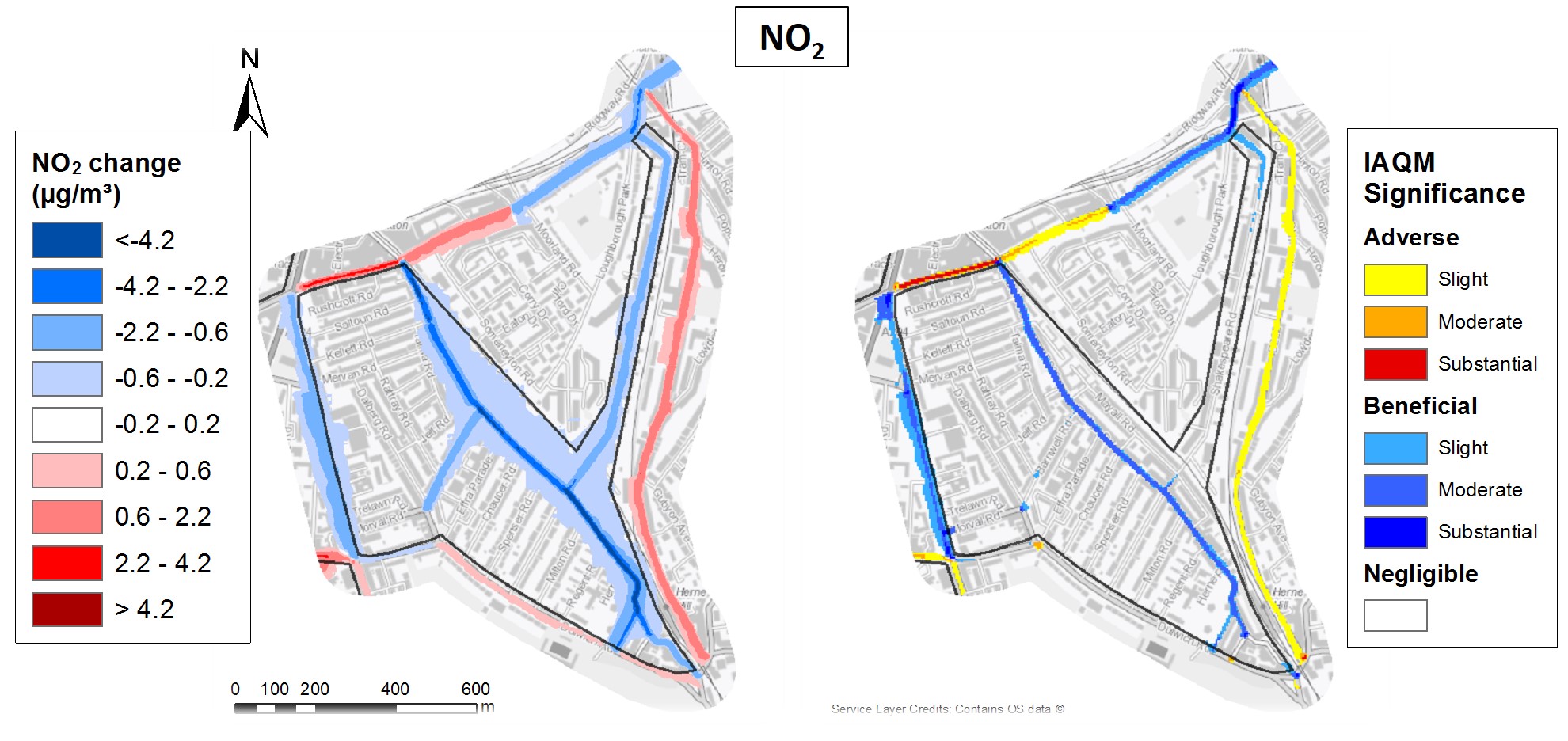
As part of an emergency transport response to the COVID-19 pandemic, Low Traffic Neighbourhoods (LTNs) have been introduced in many UK local authority areas, to help people safely walk, cycle and use public transport.
CERC consultants have evaluated the air quality impact of LTN schemes, including five schemes in the London Borough of Lambeth and the Walworth and Dulwich schemes in the London Borough of Southwark. Using local traffic monitoring data as input, the modelling assessments consider pre-scheme and post-scheme scenarios to assess the air quality impact of these LTNs.
CERC's ADMS-Urban and emissions inventory tool EMIT were used for the modelling. In addition to local traffic data, the model set-up used data from the London Atmospheric Emissions Inventory.
Concentrations of NO2, PM10 and PM2.5 were modelled on a grid of receptor points within each LTN, to generate high resolution maps for the scheme areas. Model output was also generated at sensitive receptor locations, such as schools and hospitals.
LTN monitoring reports for Lambeth can be viewed on the Council website. Where LTNs are finalised, CERC reports are available to view, for example for the Railton LTN. The figure shows the change in annual average NO2 concentrations at Railton LTN, assessed using significance criteria from EPUK and IAQM guidance for Land Use Planning & Development Control.
A presentation on the assessment of LTNs from the 2021 ADMS User Group Meeting is available to view on the CERC website presentations page.
Optimising ADMS-Urban modelling using low cost pollution sensor data
CERC participated in a project to optimise ADMS-Urban modelling using data from a network of low cost pollution sensors. This work forms part of a wider collaboration between CERC, Cambridge University, Cambridge City Council, Cambridgeshire County Council and AQMesh to investigate how modelled and monitored data can be used together to improve urban air quality assessment.
The optimisation scheme, developed at CERC, minimises the part of dispersion model error which is due to emissions data error by adjusting emission rates on an hourly basis to optimise model performance in comparison with sensor data. The scheme accounts for estimated uncertainty in the sensor and emissions data, with complex co-variances between individual source emissions error and individual sensor error. The initial scheme design and results were presented at the Institute for Air Quality Management (IAQM) conference for dispersion modellers, DMUG 2017, with the presentation available online.
CAMS: Copernicus Atmosphere Monitoring Service
The EU's Copernicus Atmosphere Monitoring Service (CAMS) combines state-of-the-art atmospheric modelling with Earth observation data to provide operational services such as:
- Daily near-real-time European air quality forecasts there is a map on the CERC homepage which shows the latest CAMS forecast for the UK;
- Daily near-real-time forecasts of global atmospheric composition;
- Reanalyses providing consistent multi-annual global datasets of atmospheric composition;
- Reanalyses providing consistent annual datasets of European air quality;
- Policy-related datasets, such as source attribution, valuable to policy users, which add value to "raw" CAMS datasets such as concentration;
- Solar and UV radiation products;
- Greenhouse gas surface flux inversions for CO2, CH4 and N2O;
- Climate forcings from aerosols and long-lived (CO2, CH4) and shorter-lived (stratospheric and tropospheric ozone) agents; and
- Anthropogenic emissions for the global and European domains and global emissions from wildfires and biomass burning.
CAMS is led by the European Centre for Medium-range Weather Forecasting (ECMWF), which is based in Reading in the UK and Bonn in Germany. CERC's role in CAMS is as part of the 'User Intelligence' team, working in partnership with the German Aerospace Agency DLR, the Norwegian Air Research Institute NILU and independent solar energy expert Etienne Wey. CERC took a similar role in the predecessor MACC projects. The overall goal of the 'User Intelligence' team is to ensure the best possible use of the CAMS products by its users, through:
- Understanding and documenting user requirements;
- Organizing user workshops and additional user feedback mechanisms; and
- Monitoring the service product portfolio against the user requirements.
Air quality modelling for Zagreb
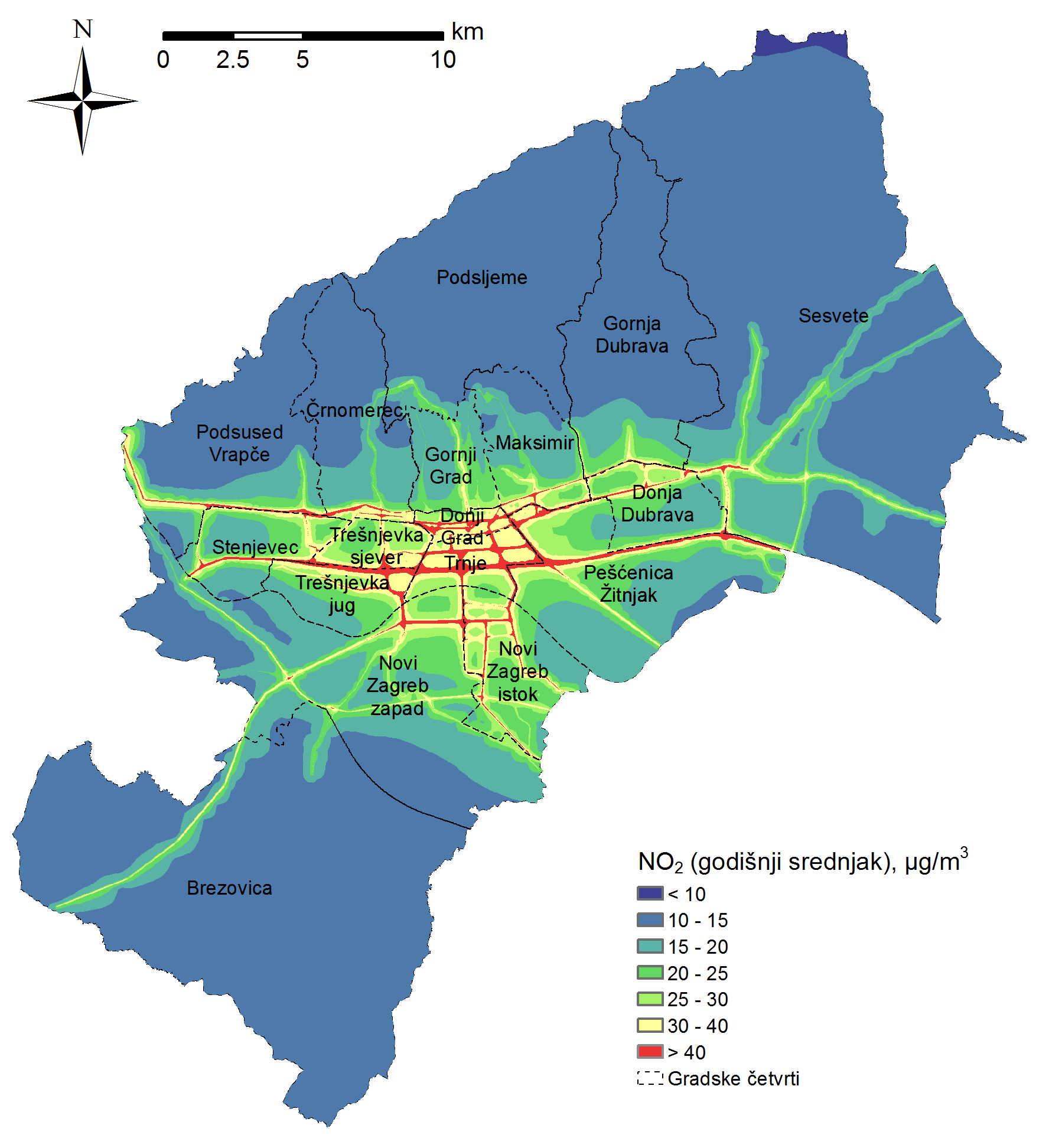
The Croatian environmental consultancy firm EKONERG completed an air quality modelling project for Zagreb City Office in which ADMS-Urban was used to model air pollution levels in Zagreb at street-scale resolution. EKONERG developed a local scale emissions inventory for the project and verified the model predictions at three urban background monitors within the city. The modelled concentrations of NO2 and PM10 were used as input to population exposure calculations.
The background concentration data used in the study were extracted by CERC from the CAMS European-scale air quality ensemble re-analysis product. These data were provided to EKONERG in .bgd file format, for direct inclusion in ADMS-Urban. If you are interested in obtaining European or global modelled background concentration data suitable for use with the ADMS models please contact us.
Follow this link to view the air quality map at higher resolution.
Defra Urban Model Evaluation
Defra carried out an urban modelling intercomparison study based on validation against London monitoring data with the final report published in 2013. CERC ran ADMS-Urban using LAEI emissions to calculate concentrations at monitoring sites, source apportionment and areas where air quality objectives were exceeded. In general ADMS-Urban was found to perform well in comparison with measurements and when compared to the other models and modelling systems considered, some of which also included components from the ADMS family of models.
Coupling Urban and Regional processes: Effects on Air Quality (CureAir)
CERC collaborated with the Universities of Edinburgh and Leeds and the Centre for Ecology and Hydrology on the NERC-funded CureAir project which investigated regional and local effects on urban air quality. CERC contributed to a coupled EMEP4UK and ADMS-Urban model for London, with MAQS (formerly ADMS-Urban RML) developed to send ADMS-Urban runs to the ARCHER high-performance computing system.
Working in collaboration with the University of Leeds, the ADMS-Urban GRS chemistry scheme was evaluated in comparison with the Master Chemical Mechanism. CERC also extended the ADMS-Urban chemistry scheme to include some effects of HONO and Isoprene. Additional work involved further evaluation of the coupled model results and investigation of the effects on air quality of the urban heat island temperature predicted by the ADMS-Urban Temperature and Humidity model under current and future climate scenarios.
Source apportionment analysis for Londons bus fleet
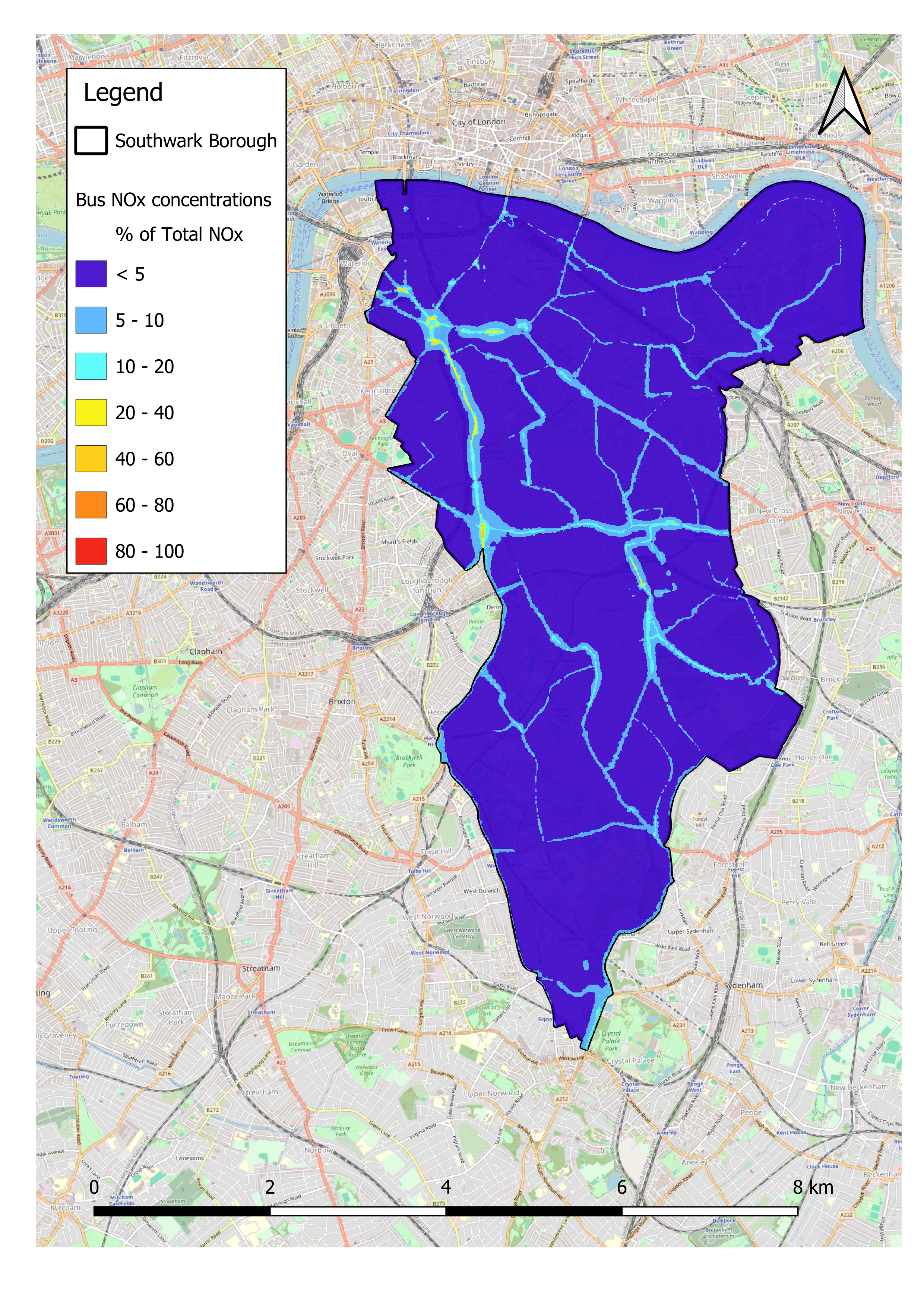
Source apportionment results for NOx. Concentrations due to bus emissions shown as proportion of concentration from all emissions sources
The Transport for London (TfL) red-liveried bus fleet are part of the citys identity, but were a key area for improvement in the Mayor of Londons 2018 Environment Strategy. Southwark Borough Council commissioned CERC consultants to assess the contribution of bus emissions to total pollutant concentrations in Southwark.
Using ADMS-Urban and EMIT, CERC created air quality maps of the borough for nitrogen dioxide and particulates, based on all emissions and then on bus emissions only. Pollutant concentrations at a large set of roadside receptors along Southwarks bus routes were also calculated.
Traffic data were taken from the London Atmospheric Emissions Inventory, and EMIT was used to create a traffic scenario including only buses.
At locations where the modelled annual average NO2 objective was exceeded, buses may have contributed less than 10% of the total NOx, as seen along Old Kent Road. In contrast, at Elephant Square and St. Georges Circus, buses could have been responsible for over 40% of the total NOx. This highlighted key areas where improving bus infrastructure would result in tangible improvements to air quality.
An Integrated Study of Air Pollution Processes in Beijing (AIRPRO)
CERC were a partner in the NERC-funded AIRPRO project along with ten UK universities, two other research organisations, three Chinese research institutes and one Chinese university. The project aimed to improve the understanding of Beijing's air quality by conducting two intensive measurement campaigns and using the data to inform model developments. A linked PhD studentship aimed to develop ADMS-Urban to predict interactions between haze and air quality, by allowing particulate concentrations and humidity to affect the meteorological conditions and the solar radiation available for local photochemistry.
Process analysis, observations and modelling Integrated solutions for cleaner air for Delhi (PROMOTE)
CERC collaborated on the NERC-funded PROMOTE project with five UK universities and Indian research institutes. This project investigated the interactions between meteorological processes such as winter fog events and poor air quality, as well as the relative importance of local and regional pollutant emissions and possible mitigation approaches. ADMS-Urban was used to model street-scale air quality in Delhi.
Reviews on Urban Dispersion for ADMLC
CERC conducted a review of 'Dispersion from Accidental Releases in Urban Areas' in 2003 and also subsequently contributed to 'A review of urban dispersion modelling' in 2013. Both reviews were conducted for ADMLC (Atmospheric Dispersion Modelling Liaison Committee).
The 2003 report considers dispersion from localised sources released suddenly, or over longer periods, in urban areas, together with the related air flow and meteorology. It considers these phenomena and their modelling over the three spatial ranges relevant to urban areas, namely mesoscale, neighbourhood and building/street scales. The report reviews current understanding, experimental and numerical simulation data and the relative merits of different modelling approaches.
The 2013 report focuses on advances in the understanding of urban meteorology and dispersion from localised sources in urban areas, with special emphasis on recent developments since the 2003 review.
Smoke control
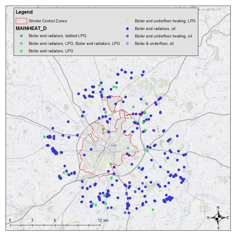
In 2022, when the City of York Council, UK, were considering additional measures for smoke control actions, including a potential extension of the citys Smoke Control Area (SCA), CERC consultants generated GIS datasets to provide insights into solid fuel use across York, to aid the Councils decision-making.
Fuel use data from Energy Performance Certificates (EPCs) and Council data for wood burner installations were mapped using address locations from the Local Land and Property Gazetteer.
Key insights from the mapping included:
- Solid fuel as a heating source is more common outside the SCA;
- Outside the SCA, properties using solid fuel as the main fuel are, on average, older and larger, compared to those inside the SCA;
- The data show a link between high levels of solid and liquid main fuels, and lack of access to the mains gas network; and
- Properties using liquid fuel as the main fuel and solid fuel for secondary heating are predominately outside the SCA, as shown in the figure. The level of solid fuel use in such properties may be sensitive to liquid fuel prices.