
CERC — Environmental Software and Services
- Overview
- Air pollution modelling
- ADMS 6
- ADMS-Roads (Extra)
- ADMS-Urban
- MAQS
- ADMS-Airport
- ADMS-Screen
- Feature comparison
- Emissions management
- EMIT
- Wind energy and airflow
- FLOWSTAR-Energy
- Accidental releases
- GASTAR
- LSMS
- ADMS-Puff
- ADMS-STAR
- Managing model runs
- Run Manager
- Model evaluation
- Model Evaluation Toolkit
- Meteorological data processing
- WRFtoMet
- Related Documentation
- User guides
- Technical specifications
- Model validation
- Newsletters
- Publications
- CERC co-author publications
- CERC software publications
- Presentations
- Other information
- Traffic emissions
- Prices
- Free demo
- Visualisation tools
- Current software versions
- System requirements


EMIT
Comprehensive emissions inventory toolkit
What is EMIT?

EMIT is a comprehensive tool for compiling and editing emissions inventories, which allows simple, fast calculation and analysis of emissions.
Typical applications include:
- Emissions calculations across large urban areas for dispersion modelling with ADMS-Urban
- Predicting the impact of Clean Air Zones and Low Emission Zones on emissions of toxic pollutants and greenhouse gases
- Source apportionment: quantifying the contributions from particular road vehicles such as diesel cars to emissions and concentrations (when using EMIT with ADMS-Urban)
- Producing greenhouse gas emissions inventories
Who uses EMIT?
Current users of EMIT include government bodies and local authorities across the United Kingdom and elsewhere, as well as environmental consultancies and research institutions. All users of ADMS-Urban and ADMS-Airport are highly recommended to use EMIT to store and manipulate the typically large quantities of data involved in these types of modelling. ADMS-Roads users will also find that EMIT can speed up the input and manipulation of emissions data for dispersion modelling.
Why use EMIT?
Traditionally emissions inventories are developed with laborious and error-prone methods such as complex spreadsheet manipulations or GIS calculations. EMIT can substantially simplify the process. For example:
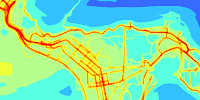
| Comprehensive datasets | EMIT contains over fifty emissions calculation datasets for sources such as road and rail traffic, airports and aircraft. |
|---|---|
| Visualisation | The EMIT Mapper can be used to visualise and edit input and output data. |
| Editing | Emissions and activity data can be edited individually on a source-by-source basis or by applying changes in bulk to multiple sources. Source geometry can be edited in the EMIT Mapper. |
| Speed | EMIT’s simple, fast features for emissions calculation and manipulation will save time and increase productivity. |
| Import | Data can be imported in the following formats: comma-separated text file (CSV), ArcGIS shape file or MapInfo MIF. |
| Export | EMIT output can be exported in the following formats: CSV and ArcGIS shape file. The CSV format can be imported directly into ADMS-Urban and ADMS-Roads for dispersion modelling, including ADMS-Urban grid sources which are automatically calculated by EMIT. |
| Consistency
|
EMIT’s automatic calculations ensure a consistent, verified and traceable methodology for emissions assessment. |
| Auditing
|
EMIT gathers together the input and output data for emissions calculations into a single file, which inherently provides an audit trail for the assessment procedure. |
Scenario assessment

When local authorities develop Air Quality Action Plans for an urban area, an important aspect is estimating the emissions consequences of traffic management schemes such as Clean Air Zones and Local Emission Zones. EMIT has been specifically designed to help with this task. EMIT allows you to consider the effect on emissions of the following aspects, both individually and in combination:
- Projected changes in traffic flows due to national trends
- Projected changes in national fleet composition through the introduction of cleaner technology with time in response to national and international emissions legislation
- Changes in local fleet composition, traffic flows, and speeds through local interventions
The effect on emissions can be quantified for individual toxic pollutants and greenhouse gases, in total and as contributions from specific road vehicles such as diesel cars.
The figure below shows an approach for investigating the effectiveness of traffic management schemes. Four different scenarios are considered:
| Base case | The current situation without traffic management. |
|---|---|
| Future year | Predicting changes in future emissions due to national trends in traffic flows and fleet composition in a "business as usual" scenario without traffic management. |
| Impact in base year | Predicting changes in emissions due to the impact of a proposed local intervention on traffic flows, fleet composition, and traffic speed. |
| Impact in future year | Predicting future emissions in the future year under the local intervention and national expected trends. |
Comparing the different emissions from these scenarios allows a clear assessment of the impact and effectiveness of the proposed scheme. EMIT enables the user to assess multiple scenarios in a fraction of the time required by traditional methods.
