
CERC — Environmental Software and Services
- Overview
- Air pollution modelling
- ADMS 6
- ADMS-Roads (Extra)
- ADMS-Urban
- MAQS
- ADMS-Airport
- ADMS-Screen
- Feature comparison
- Emissions management
- EMIT
- Wind energy and airflow
- FLOWSTAR-Energy
- Accidental releases
- GASTAR
- LSMS
- ADMS-Puff
- ADMS-STAR
- Managing model runs
- Run Manager
- Model evaluation
- Model Evaluation Toolkit
- Meteorological data processing
- WRFtoMet
- Related Documentation
- User guides
- Technical specifications
- Model validation
- Newsletters
- Publications
- CERC co-author publications
- CERC software publications
- Presentations
- Other information
- Traffic emissions
- Prices
- Free demo
- Visualisation tools
- Current software versions
- System requirements


ADMS-Roads
Comprehensive software for modelling road traffic pollution
What is ADMS-Roads?
The ADMS-Roads air pollution model is a comprehensive tool for investigating air pollution problems due to a small networks of roads. ADMS-Roads allows the accurate modelling of traffic emissions due to the inclusion of traffic-induced turbulence and a street canyon module in the dispersion modelling, as well as the calculation of emissions from road traffic data, using a database of emission factors.
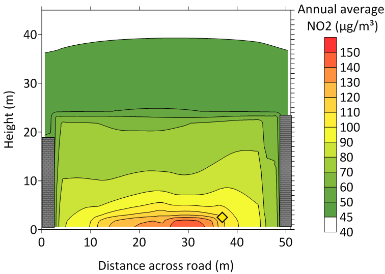
Vertical cross-section of annual average NO2 concentrations at the site of the Marylebone Road monitoring site in London (shown by diamond). From Hood et al. (2021).
ADMS-Roads combines many of the scientific capabilities of CERC's air quality management system ADMS-Urban with an easy-to-use interface and output pollutant concentrations of very high street-scale (metres) resolution. Model operation is similar to other ADMS models, making it a simple task for anyone familiar with ADMS 6 to extend their modelling skills to cover road sources.
For large towns and cities ADMS-Urban is the preferred tool.
Who uses ADMS-Roads?
The ADMS models have been extensively used in local air quality management. ADMS-Urban, on which ADMS-Roads is based, is used across the world for air quality management and assessment studies of complex situations in towns, cities, motorways, counties and large industrial areas.
In the UK, over 70 local authorities have used ADMS-Urban to help with their review and assessment and in developing Clean Air Zones (CAZs), Low Emission Zones(LEZs), air pollution action plans and remedial strategies. The ADMS models have also successfully been used for examining planning applications and EIA for proposed industrial, retail and domestic developments.
ADMS-Roads is currently used by a number of consultancies in the UK and abroad.
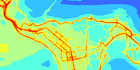
Annual average NO2 concentrations at ground level for study in Hounslow (London) with elevated road (M4, bends to north-west) and ground-level road (A4, continues to south-west).
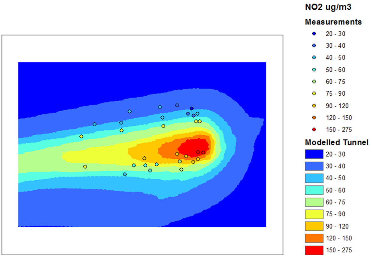
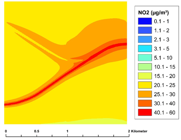
Comparison of modelled and measured average NO2 concentrations for a 4-week period at the portal of Bell Common Tunnel (M25, London).
Why use ADMS-Roads?
The science of ADMS-Roads is significantly more advanced than that of most other air dispersion models (such as CALINE, ISC and R91) in that it incorporates the latest understanding of the boundary layer structure, and goes beyond the simplistic Pasquill-Gifford stability categories method with explicit calculation of important parameters. The model uses advanced algorithms for the height-dependence of wind speed, turbulence and stability to produce improved predictions.
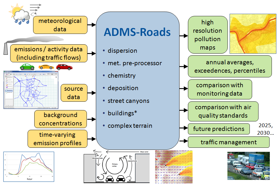
This diagram shows some of the possible inputs to and outputs from the model, and some of the modelling options available. * The buildings module is only available in certain license packages.
Many factors are important in predicting pollutant concentrations. ADMS-Roads has been developed with a number of features to simplify the modelling process and help users. For example:
| Visualisation | ADMS-Roads is supplied with the Mapper and has links to Surfer contour plotting package. The Mapper can be used to enter and display input data and display output, usually as colour contour plots. |
|---|---|
| Emissions inventory | Source and emissions data can be imported from text files created by the user or exported from CERC's Emissions Inventory Toolkit, EMIT. EMIT contains current and future emission factors including those for vehicles, industrial processes and fuel consumption. |
| Emission factors | Defra's Emission Factor Toolkit emission factors. |
| Source-oriented gridding | ADMS-Roads includes source-oriented gridding option which places extra output points in and adjacent to road sources to give excellent spatial resolution in areas of particular interest. |
| User-defined outputs | The user defines the pollutant, the averaging time (which may be an annual average or a shorter period), any percentiles and exceedence values that are of interest, and whether a rolling average is required. The output options are designed to be flexible to cater for the variety of air quality limits which can vary between countries and over time. |
Modelling scenarios and future years
In most cases, ADMS-Roads is first used to model the emissions from a base case scenario, that is, data (emissions, meteorology, background, etc.) are used to produce results that can be verified against locally monitored data from a recent previous year or the current year. Once the base case scenario has been validated, it is possible to investigate different scenarios, for example:
Impact of major development
ADMS-Roads is often used to compare air quality before and after major developments. An emissions inventory is compiled using the best available estimates for after the development. ADMS-Roads allows many What if? scenarios to be tried out, predicting concentrations at key receptors or across a wider area.
Future years
The majority of air quality limits are objectives for future years. These scenarios can be modelled in ADMS-Roads using Defra's Emission factor toolkit emission factors for future years, future predictions from EMIT or the user's own estimate. Likely changes in traffic flows, fleet compositions and background concentrations if known, can also be included in the future scenarios.
Traffic management
If the predictions for future years indicate that concentrations of certain pollutants are likely to exceed the objectives, it is usual to consider traffic management and emission reduction scenarios. For example, some local authorities in the UK have introduced Low Emission Zones within which only vehicles that meet a particular low-emission standard are allowed. The effect on air quality of introducing such measures can be investigated using ADMS-Roads. CERC's Emissions Inventory Toolkit, EMIT can be used for investigating the effect on emissions.